GREAT BRITAIN CHURCH MAPPING
Locating the Harvest
Have you ever walked past a spiritual harvest field and didn’t notice it? Do you know if the people 20 minutes down the road from you know Jesus?
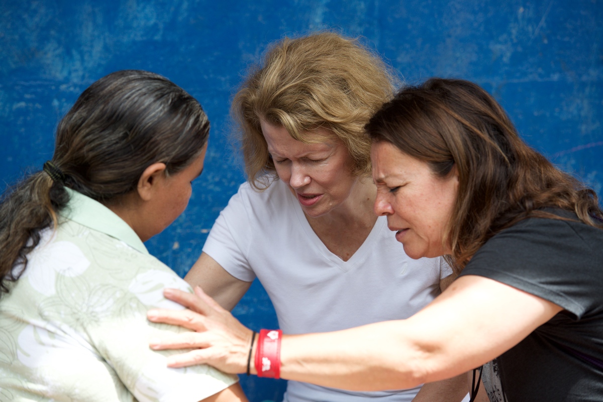
Jason and Shiela Fisher, Assemblies of God World Missions global workers, knew God had called them to serve in England. It was obvious to the Fishers that the need was everywhere, but that didn’t help them know where to focus. “Unless the Holy Spirit prophetically gives you a town name, how do you discern where the need is the greatest?” Jason asked.
Jason started studying demographics — who lived where, who believed what, and what churches were there — and put that information into a spreadsheet. When he discussed his findings with Sheila, she asked to see a map. They printed a Google Maps screen shot and began circling towns on the map with a highlighter. They quickly realized the great need, and that they would need a better map.
At the same time, professional cartographer, Phillip Henderson, approached his pastors at First Assembly, Montgomery (AL) and asked if there was any way he could help a missionary develop ministry-focused digital maps. After connecting with Jason, they built a beta-test map for Assemblies of God Great Britain (AG GB). With a goal of planting 400 new works in 6 years, the national leadership asked Jason to continue developing the map to show local pastors the needs right on their doorstep.
“What if we just sent 20 people, 20 minutes down the road and see what God did?” says Glyn Barrett, AG GB national leader.
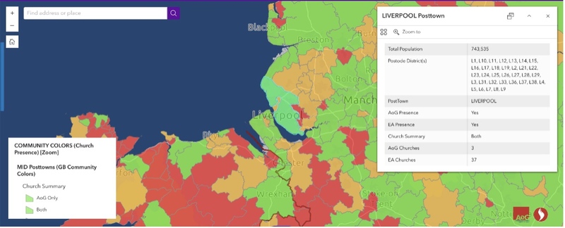
When pastors use the website, they track how many people live in a region, how many are believers, and how close they are to a church. The map has different filters and magnifications that illustrate local spiritual needs. One simple layer categorizes each community in green, yellow, and red zones. Green zones have at least one AG GB church. Yellow zones have churches that are members of the Evangelical Alliance, but no Assemblies of God churches. Red zone areas have neither.
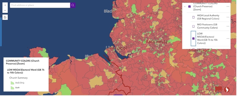
Liverpool, for instance, is a “green zone” at one magnification. There are 3 AG GB churches in the city and 40 evangelical churches total. However, looking closer, the map indicates that these congregations serve three-quarters of a million people, meaning that each Evangelical Alliance church would need to reach 19,000 people. “Instead of looking at Liverpool as one big community of over 700,000 people, we can redraw the lines into communities of 7,000 people and see that most of the city is a ‘Red Zone.’
(Community Categorization)
(Neighborhood Categorization)
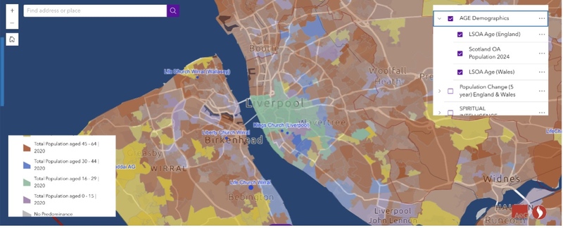
Using filters for age and religious affiliation, pastors can also see that certain neighborhoods have a younger population, or a majority non-religious population.
(Age)
(Religion Majority)
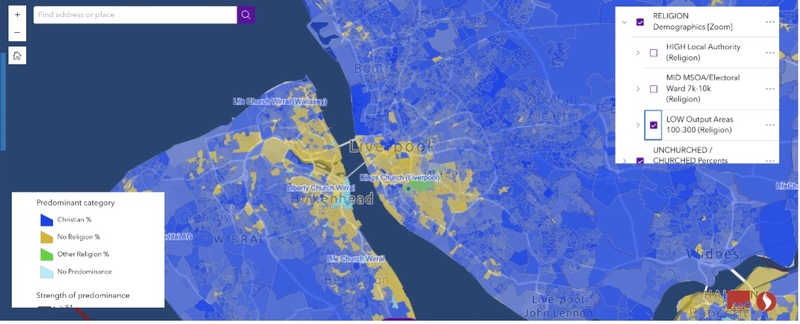
AGWM global workers Chris and Amy Hales researched Liverpool’s demographics when they moved there to plant a church. As they were considering where to plant, they worked with Jason and learned that downtown Liverpool had a thriving student community with a deep spiritual need.
“Using Jason’s map, I could narrow it down to the street we’re putting the church on,” says Chris. “Fifty-five percent of one part of the street and 58% on the other part of the street is non-religious. No religion, no Buddhism, no Islam, nothing”
With this information, the Hales moved into the city and found spiritually hungry people everywhere. At coffee shops, in business, and walking around their block, they befriended neighbors who were secular, yet open to the gospel. “It was a good asset for us. We always had a desire to reach the non-churched people, and this is where all the non-churched people are,” states Chris.
Like the Hales, British pastors and AG GB leaders have been using Jason’s mapping tool to focus their new planting efforts. Jason reports that whenever he presents the map data, numerous pastors tell him that this information has confirmed what God has already placed on their hearts.
“It’s not about the computer telling us where to go or what to do,” says Jason. “It’s about using this tool as part of our discernment process for what God’s already doing.”
Jason is amazed at the way God uses every skillset to establish His church among all peoples. “None of this would have happened if a lay person in Alabama hadn’t brought his work skills to the Lord and asked, ‘What can you do with loaves and fishes?’” Jason reflects. “I’m a worship pastor by training and here I am making maps that inspire and inform hundreds of church plants.”
Across Great Britain, pastors are seeking the Holy Spirit and using these tools to seek out the harvest. Through partnership with the Fishers, the AG GB is establishing the Church in Great Britian’s most spiritually needy towns, neighborhoods, and streets. We celebrate with the AG GB because they have planted more than 120 new churches since May 2022, and many more are in the pipeline.
Jason concludes, “Whenever I share this with a church the overwhelming response is, ‘Wow! I wish we had this for the U.S.’” Recently, Jason has been working with Church Multiplication Network to collaborate on a similar map for the U.S. Gerad Strong, CMN director of training and church health adds, “We partnered with Jason to design a robust mapping platform with customized data points, enabling our networks to make more informed decisions about planting, multiplying, and partnering — ultimately advancing the vision of a healthy church in every community.” CMN is currently working with districts/ministry networks to train them in using this software. For more information, contact your district ministry network.
Alex Goodrich
AGWM Communications